Paddling in Arkansas and Arizona
October and November 2003
Finding new places to paddle in new areas we visit is a big part
of our traveling/paddling life these days. Running our store and
teaching paddling takes most of our time in the summers, so we travel
south winters. We stay in state and national parks as well as Corps
of Engineers and BLM campgrounds. We carry our sea kayaks and folding
canoe, motorcycle, and bicycles with us and have found beautiful
paddling in Florida, Texas, Arizona, New Mexico and many other states.
However this year we visited Arkansas and Arizona, (both unlikely
paddling states we thought).
It was our first visit to Arkansas, and we were just going to drive
through, but our first stop at Lum’s Mountain Campground in
tiny St. Joe changed our minds. Perhaps it was Lum’s charisma
and enthusiasm, or perhaps it was the beautiful mountains, small
towns, great motorcycling and friendly people. Then too, perhaps
it was the Buffalo National Scenic River. Whatever it was, we stayed
2 weeks. St. Joe lies on Route 65, a beautiful scenic road running
through much of the Ozarks. It takes you from Branson, MO much of
the way south to Little Rock.
Unfortunately a long drought had made the Buffalo too low to enjoy
paddling in our 16’ Pak Canoe, so we were limited to enjoying
views of it from our car and motorcycle trips. We would love to
return to paddle this river when the water is up. You can do a week-long
trip or several different day trips on it. We were told that the
highest rapids were class 2 and that the majority of the length
is quick-water and class 1.
On the map we located Greer’s Ferry Lake and several Corps
of Engineers campgrounds around it. We selected Choctaw, moved there,
found a beautiful campsite and had a wonderful paddle in our sea
kayaks.
Next we moved to the Hot Springs area (take Route 30 from Little
Rock and then 70 and 270) and Lake Ouachita where we stayed at the
Corps of Engineers Crystal Springs and Charlton campgrounds. This
lake is 40 miles long, has a very irregular shoreline and more islands
than we could count. A map/chart of the lake is essential as one
could easily become lost on it. Seeing the hundreds of miles of
shoreline devoid of development from the overlook on top of Hickory
Mountain was a real joy. We paddled many miles, circling around
several of the large and small islands. Markers for the larger boats
were helpful in letting us know exactly where we were.
As colder and rainy weather moved in, we moved on to Rainbow Plantation,
a SKP campground just west of Foley, AL. We were 10 miles from the
gulf here and located a couple tidal rivers to paddle in, the Fish
and Magnolia as well as Mobile Bay. But that is another story!
Earlier, in February and March of 2003 we traveled in Arizona and
paddled in three different lakes. The first was Patagonia Lake at
Patagonia State Park. The park and town of Patagonia, AZ are south
of Tucson near Nogales on the border of Mexico. Take Route 83 from
Exit 281 on Interstate 10. Turn right on route 82 in Sonoita, follow
it past the funky little town of Patagonia and turn right again
at the sign for the park. This is a small lake but has nice spots
for picnics and scenery includes cactus growing from rock ledges,
cattails galore and little inlets for paddlers. It is a birders
paradise.
There are a number of nice campsites here at the park and a beach
on which to launch any boat as well as a boat launching ramp. In
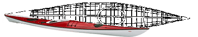
the basement of our motorhome we carry a 16’ canoe made by
Pakboats. It folds into a bag the size of an army duffle and also
stores easily in a closet, or the trunk of a car and weighs just
50 lbs. It takes about 25 minutes to put together the 2nd time and
paddles quietly and efficiently. It was perfect for exploring this
lake.
From here we moved to Lost Dutchman State Park in Apache Junction,
AZ, 25 miles east of Phoenix and really in the country at the base
of the spectacular Superstition Mountains. This area offers excellent
hiking and motorcycle riding as well as paddling. We paddled in
both Canyon and Saguaro lakes. These are man made but follow canyons
with cliffs rising as much as 500’ straight up from the water.
We encountered few boats on Canyon but several on Saguaro Lake.
To get to Canyon Lake, follow Route 88, the Apache Trail, east from
Apache Junction toward Tortilla Flats (a cool place to stop for
ice cream, lunch or just to listen to real cowboy music). The lake
is beside the road and the put in easy to find, we used a picnic
area rather than the boat launch for our sea kayaks. This is my
favorite Arizona lake at this point. The scenery is awe inspiring
and the setting remote. The Apache Trail is worth the drive, even
without the kayaks.
Saguaro Lake is found by taking Route 207 north between Mesa and
Apache Junction. It is a short drive and this lake seems to get
a lot more use. There is a nice restaurant overlooking the lake
where you can get a snack or a full meal. We put in from a picnic/beach
area again rather than the busy boat launch. Following the canyon
for several miles was interesting, and people were using the hiking
trails along the desert-like shore. We found a nice quiet and secluded
place for a picnic in spite of all the boat traffic. I would recommend
going here on a weekday for a more peaceful paddle.
This winter we travel to the far west of Arizona and plan to camp
on the lower Colorado River. We will let you know about this after
we have been there. Our kayaks are British-made, one an Explorer
from Nigel Dennis in Wales and the other a Valley Aquanaut. The
kayaks and bicycles ride on the top of our car (which we tow) and
the motorcycle is carried on the back of our RV.
--by Bill Zeller, Country Canoeist
|