Blue Hill Fallsfrom Blue Hill, Maine |
 |
| Paddle
Trip |
| Blue Hill Bay, South of
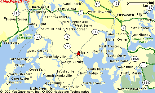
Bucksport, Maine. The Road Trip: From the South: Take Route 1 to Bucksport and continue another 3 miles to East Orland. Turn right onto Route 15 south (sign for Blue Hill). Follow Route 15 apx. 13 miles to the town of Blue Hill. Take a right at the "T" intersection, continue 50 to 100 yards, and then turn left onto the small street leading down to the Public Boat Launch. From the North: Take Route 1 south from Ellsworth (about 17 miles). Turn left onto Route 15 in East Orland (sign for Blue Hill), and then continue as above. |
|
||
 |
|||
| Trip Summary: An sea kayak trip that combines
one of Maine's most beautiful and protected harbors with semi-protected scenic
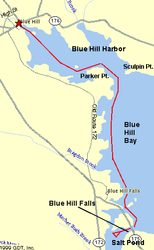
coastline and an impressive reversing falls. The Launch: The public launch area consists of a wide concrete boat ramp. There are also some public docks which can be used to launch sea kayaks. Paddling Time & Distance: 2 hours. Longer if you want to play in the falls. 5 - 6 miles. Route: Head southeast past the ledges -- and (in the summertime at least) a plethora of moorings -- to skirt around Parker Point. After passing through the relatively narrow mouth of the harbor and rounding Parker Point, head south along the coast, past many protected coves, fine homes and summer homes to the outlet to Salt Pond, which is actually split in two by an island (see map). Blue Hill Falls is located adjacent to the bridge over the southerly outlet of Salt Pond. Paddling Tips: The public boat launch in Blue Hill is best used at mid to high tide. (At low tide you will face a considerable mud flat -- yech!) Blue Hill Falls is best at 1 - 2 hours before high, so if you want to run the falls, you should plan accordingly. On the other hand, if you make the return trip up Blue Hill Harbor on the returning tide, you will benefit from a nice 1 - 2 knot push. If the tide is right (see above)once you pass under the bridge at Blue Hill Falls, you can run the falls repeatedly by riding the return eddy along the northern shoreline. (On an outgoing tide, there are no usable eddies and so its harder to make it a play spot). Watch out for: I paddled this trip in a dense (and I mean DENSE) fog, and so it was tough to watch out for anything. In fact, it took several attempts just to find the (relatively narrow) mouth of the harbor. The trip is fairly protected, unless you're running into a Nor'easter. Blue Hill Falls is likewise less dangerous than it looks, as there are no rocks to hit except those along the immediate shoreline. Natural Features: Blue Hill Falls is an unusual reversing falls created by the tide being funneled into a narrow channel to create high (up to 3 feet) standing waves -- 100 - 200 yards total length, depending on the tide. Runnable by raft, inner tube, canoe, or kayak. Other Landmarks: There is a golf course at Parker Point. Stretch Your Legs: Even if you don't want to run the falls yourself, you can pull ashore and watch other people more foolish than you. Maybe have lunch while you watch. One Paddler's Story: Ray Wirth paddled this trip in an extremely dense fog. He learned the importance of carrying a chart as he found locating the mouth of the harbor to be quite a challenge. And yes, after some hesitation, he did "shoot" the falls in his sea kayak and then went back for more. |
|
| Previous Trip | Next Trip | List of Trips | Submit a Trip | Home |