| Graffam Island from Spruce Head |
 |
Sea Kayak Trip |
| Muscle Ridge Channel, South of
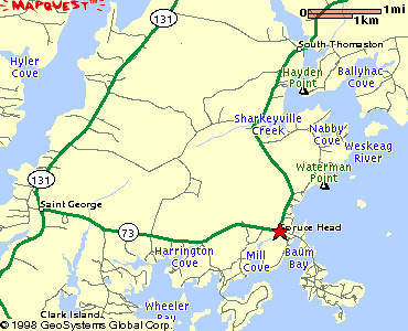
Thomaston, Maine The Road Trip: From Rockland, Maine, turn right off Route 1 onto Route 73 and proceed south about 7.5 miles (passing through South Thomaston along the way). Turn left and follow the signs for Spruce Head Island. The hand carry boat launch (with parking) is from the second bridge, less than a mile off Route 73. |
 |
||
| The Paddle Trip: Trip Summary: A scenic and varied sea kayak trip which includes an active working harbor (Spruce Head Island), some open water, many ledges, and a variety of islands. Distance: 9 nautical miles. Paddling time: 3 hours. The Launch: At all but low tide, you should launch on the southwest side of the bridge and proceed counterclockwise.(The mud flats there are a soggy carry at low tide.) The Route: If possible, launch after high tide, head southwest out of the harbor and then south and southeast along the shoreline to Spruce Head Harbor with its scores of lobster boats. Pass down the channel and under the bridge that leads to Burnt Island, and then cross to Graffam Island, about 1.5 nautical miles to the southeast. After skirting the northern shore of Graffam Island, head almost due north, past several small ledges and islands, to Tommy Island. Watch Out For: The winds and currents here can be quite strong, often out of the southeast. Tips: If possible, paddle this trip early in the day before the wind comes up and / or in calm conditions. Avoid the harbor southeast of the launch at low tide. Natural Features: Views of the Camden Hills to the northeast; Native American shell mounds on some of the islands: Hurricane Ledge, High Clam Ledge, Garden Island; other ledges; a variety of sea birds, including scoters, which inhabit the ledges. Other Landmarks: Two Bush Light is directly at your back as you paddle from Graffam Island toward Tommy Island; the old house on Tommy Island; a variety of impressive houses and cottages on Spruce Head, Pleasant, and Hewitt Islands. Stretch Your Legs: On one of the rock ledges between Graffam and Tommy islands, or on the sandbar which extends between Graffam and Bar Island at all but high tide. One Paddler's Story: Ray & Lisa Wirth paddled this trip in sea kayaks on a windy October day. They learned the hard way about the mud flats west of the launch area. |

Water Walker Sea Kayaks: |
||
| Previous Trip | Next Trip | List of Trips | Submit a Trip | Home |