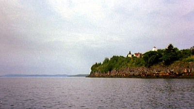
Castinefrom Fort Point State Park |
 |
Sea Kayak Trip |
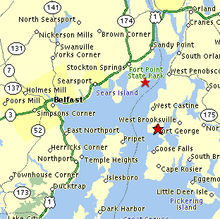
| Fort Point State Park, Cape Jellison,
Stockton Springs, Maine (Upper Penobscot Bay Region) The Road Trip: From the South: Take Route 1 north through Searsport, continue about 4 miles, and then bear right off Route 1 to enter Main Street in Stockton Springs. Continue though the small downtown section and watch for signs for Fort Point State Park. Turn right onto the Cape Jellison Road, bear left at the "Y" in mile, continue another 1.5 miles, turn left onto Fort Point Road. The boat launch and pier is off to the left and downhill from the main parking area. From the North: Take Route 1 or 1A south to Stockton Springs. Turn onto main street and then watch for the Cape Jellison Road on your left. |
 |
||
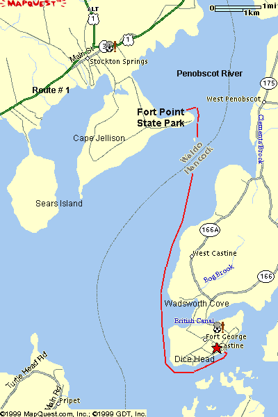
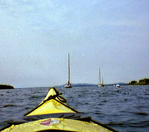
| The Paddle Trip: Trip Summary: The sea kayak trip combines two historic and scenic coastal points on opposite sides of the Penobscot River. Includes a variety of paddling conditions, currents, and scenery. The Launch: Begin with a fifty yard carry (at least it's downhill) on the grassy road leading down to the pier. From here, you can either scramble down over the rocks on the left of the pier, or continue out onto the pier itself and launch from the float at the end of it. Paddling Time & Distance: 4 hours or more; about 12 nautical miles round trip. The Route: From Fort Point ledge, head due south out the bay toward Turner Point. Reaching Turner Point, continue south along the shoreline, stopping at Wadsworth Cove if you need a break or a swim. Continue south to Dice Head and then turn east along the shoreline until you reach Castine harbor. Paddling Tips: If you depart near low tide you will gain the most benefit from the river as you head south out into the bay. On the other hand you are likely to have a tail wind on your return trip and an incoming tide would help you still further. Watch out for: The current can be a bit strong right at the tip of Fort Point -- just off from the sand bar and lighthouse. Dice Head and the entrance to Castine Harbor are other areas that always seem to be running a current (as the water flows in and out of the Bagaduce River). You will be crossing major shipping channels, including one that runs very near shore, just off Fort Point. I'm not sure I would attempt this trip in a fog. Natural Features: The craggy reddish cliffs of Fort Point, the seals of Fort Point Ledge, Wadsworth Cove with its near-sand beaches (a coarse rounded grit really, but that's pretty good for Maine) framed between rocky headlands, the cliffs of Dice Head, and the currents of the Bagaduce River. Other Landmarks: Fort Point Lighthouse and white tower, the stone tower on Fort Point Ledge. You will be able to see Sears Island and later Islesboro to the east. Stretch Your Legs: Wadsworth Cove is the Castine town beach and is open to the public. Castine is unspoiled, picturesque, quiet little town. Enjoy! One Paddler's Story: Ray Wirth kicked off summer vacation '99 by sea kayaking to Castine, eating a haddock sandwich for lunch at "The Breeze" (on the town pier), and paddling back. |
  |
||
 |
 Water Walker Sea Kayaks |
||
| Previous Trip | Next Trip | List of Trips | Submit a Trip | Home |