Verona Island,
|
|
| Paddle
Trip |
|
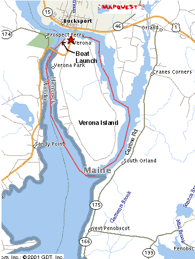
Circumnavigation of Verona Island. Verona Island lies in the mouth of
the Penobscot River just south of Bucksport, Maine. The island marks the end of
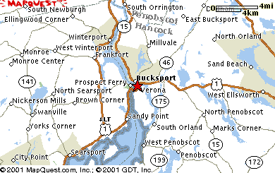
the river and the start of upper Penobscot Bay. The Road Trip: To reach Verona Island from the south, drive up Routes 1 and 3 past Searsport and Stockton Springs to Prospect. At the blinking light, take a right and immediately cross the high bridge to Verona Island. Continue on Route 1 and 3 until just before the small bridge leading off the island to Bucksport. Look for the sign on the left for the boat launch. Turn left and follow the road to the ramp and picnic area with outhouses. If approaching from the north, follow Route 15 into Bucksport. 15 will merge with 3 and 1 and you will see the stoplight, signs and bridge to Verona Island on your right. |
 |
||
|
|||
The Launch: The launch is an all concrete all tide ramp. The best direction to start is west (left) which takes you down the western side of Verona in the main channel of the Penobscot. Time and Distance: I paddled this trip on July 29, 2001 starting at 11:00 am and ending at 3:20 PM with about a 45 minute break for lunch. The distance is approx. 11 miles. Route: This trip should be coordinated with the tides. The paddler should start down the west side in the main channel no later than the last 1/3 (two hours) of the ebb tide. At the southern tip of Verona Island (approx. 5 miles from the put in) head approx. north along the east side of the island. You should wait until the tide turns to flood so you won't be paddling against the current. Paddling Tips As indicated above, this trip is best paddled in a counter clockwise position, going down the main, western channel of the |
 |
||
| Penobscot first and then returning by
the eastern channel. Be sure to catch the ebb tide to ride the river down and
the flood to go back up. The reason why the western channel should be done
first is that it takes about 2 hours (according to Dorcas Miller) for the flood
tide to overcome the hydrostatic pressure of the river current in the main
channel. This is not a problem in the eastern channel which has a much smaller
volume of water and is primarily tidal. The first 50 yards or so from the
put-in you will be fighting a current until you get to the main channel. Once
there however, the river current combined with the ebbing tide speeds you
along. Watch out for: Watch out for eddies on the western, main channel. These aren't real serious but you should be aware of them. In a southwest breeze, both the main channel of the Penobscot and the southern tip of the Island can be subjected to quite a chop, particularly during the ebb tide where the current opposes the wind. Watch out for river traffic, including large vessels, in the main channel and small boat traffic in both channels. Also try to avoid the pilings of the bridge between Verona and Prospect over the main channel. You can't miss it , it's the big suspension bridge about a mile or so from the put in. Natural Features: The western side of Verona, on the main channel consists of rocky, seaweed covered shores interspersed with small gravel beaches. Towards the southern tip, on the western side the island falls away to the south east and the gravel beaches become longer. The same type of terrain continues for about 400 yards up the eastern shore. There are some camps visible on the western side, fewer on the eastern side. I would recommend stopping for lunch or a break just after you round the southern point and wait there for the flood tide to begin. Most of the eastern shore after the first 400 yards consists of wide mud flats at low tide with a navigable channel in the middle but not a place to pull out your boat, unless you like mud. Other Landmarks: The Prospect bridge on the western side as well as Sandy Point on the western side of the main channel opposite the southern tip of Verona. Stretch Your Legs: I had lunch on a small beach about 300 yards for the southern end of the island on the eastern channel. This is really the last spot for a break without having to get too muddy. Fortunately it was only an hour and 1/2 paddle back to the put in. One Paddler's Story: Jon Sprague paddled this trip on July 29th in a Perception Vizcaya. His wife told him that people circumnavigate Greenland and Australia but paddle around Verona Island, so don't let the trip description put you off, its a nice easy days paddle when the wind and tide conditions are right. |
|||
| Previous Trip | Next Trip | List of Trips | Submit a Trip | Home |